At Cradle Mountain – part 1

[Mid-November]

It was our second day in Tasmania. Encouraged by the short distances between locations, we decided to drive to Cradle Mountain to check it out. The closer we came, the wilder the landscape, the steeper the roads, the scarier the serpentines.

Then the surprise: a huge carpark with separate areas for buses, caravans, and cars, a modern visitors centre with a Nordic-looking design, a gas station and a dump point, and a fleet of minibuses to transport visitors to the respective walks. Everything appeared extremely well organised. Even though the weather was freezing and their was an icy drizzle, the car park was half full and we saw groups of people rushing towards the entrance. In the distance, we could make out the iconic top of Cradle Mountain half-hidden in a grey cloud.

Fresh from the ferry, we were totally unprepared and could only muster the coffee shop, which was packed with shivering folks. We decided to wait until it was warmer (the forecast for the following week was subzero temperatures and snow) and come back again.

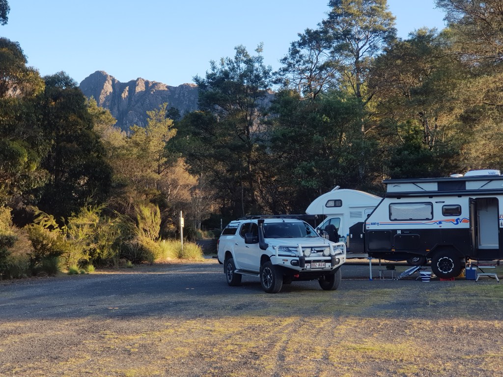
Two weeks later we were in luck: It was relatively warm and supposed to be clear. Still we took everything with us: thermals, gloves, beanies, rain jackets, hiking shoes, and sun hats. By now we knew that the warnings about the constantly changing weather were not to be ignored. Our “base camp” was at Gowrie Park, a 40-minute drive from the east at the foot of Mt Roland.

To part 2 and part 3 of our journey to Cradle Mountain

At the edge of the Central Highlands

Impressed by its name and the great reviews on WikiCamps, we booked an unpowered site at the caravan park in Golden Valley. The place had a lovely vibe, lovely caretakers, and was well taken care of. What we didn’t realise, though, was that it lies at the edge of the Tasmanian central highlands making it much colder than locations north of it. Quamby Bluff towers over the valley and marks the border between the lush fertile north of Tasmania and its austere, harsh interior.

Serpentine after serpentine going south on the Highlands Road, only a short trip by car brought us to the high plateau: an alpine region with ancient plants, lakes, and a climate similar to Iceland or Southern Chile. Icy wind gusts, low vegetation, and then suddenly the Great Lake. Stunning views reminiscent of Norwegian shorelines. Fishing shacks made of corrugated iron. Also the general vibe was harsh: if you can’t handle it stay away.

The landscape is so wild and grand that I gave up on taking any photos. Have a look here for images of the region.

The next day, we went hiking. It was like an obstacle course. Liffey Falls, a popular waterfall, was closed due to damage from the floods in October. Projection Bluff started out okay, but soon led us to a lagoon that flooded the path. After trying to find a way around it through the thick scrub, we gave up and turned around.

The Quamby Bluff summit track, however, was welcoming – at first. A lovely path past a tiny Tibetan Buddhist monastery with views across the ridges led us to a forest thick with meter-high ferns. Soon we came to a tree that had crashed across the path. We scrambled over it. Then the next tree. We scrambled around it. Then a whole set of trees across the path… we turned around and enjoyed the lovely beginning of the path a second time in the opposite direction.

Our last night at Quamby Corner/Golden Valley was cold, so cold. We woke up to 0 degrees Celsius. You can see us here recovering with chai and hazelnut brownies at a coffee shop in Deloraine 😋

What is happening today?

[Tasmania, close to Deloraine]

Minimum temperature 5 degrees, maximum 11 degrees. Wind gusts, icy rain showers. From our RV Farm Stay (a large open grassy field), we can see the snow on the mountain tops of the Western Tiers between Deloraine and Launceston. But now finally the sun is coming out!

This Farm Stay operates with an honesty box. Check out the photos below.

On the Spirit of Tasmania

It was the beginning of January 2022. We had been planning and discussing our transition from working full-time to becoming grey nomads for one and a half years. We needed something decisive to give us focus. What could it be? In the past, booking flight tickets often had done the trick. Once the ticket was booked, the journey became a reality. Now, we wouldn’t use a plane but the ferry to Tasmania. So we booked the Spirit of Tasmania for 15 November. As we found out, the ferry tickets are in high demand. Making changes to existing bookings is hardly possible during summer except if you are okay with postponing your travel for up to several months.

So, the date was more or less fixed and became our guiding light throughout the year. In the middle of October, the week before we left, a flooding crisis started to unfold in NSW and Victoria, the two states we had to cross. What did that mean for our plans? We held our nerves and left as planned three weeks before the ferry date. You can read more about this here.

So what was it like to go on the ferry? We had a look at it the day before departure. There it was, the massive new ship that could take hundreds of vehicles across the Bass Strait. Fittingly, the weather was very Tasmanian – cold and fickle, switching from sunny to overcast to wind gusts and rain.

We saw that cars and caravans were lined up hours before boarding time and decided to do the same. It was fun standing in line and chatting with other nomads. It was exciting! I felt like a kid – it was decades ago that I had last been on a ferry to an island.

We took the overnight ferry and had a small cabin at the bow with a porthole and a compact shower/toilet bathroom. People had warned us that the ride could be terrible with the recent storms. But mostly it was magical: gliding across Port Phillip Bay at dusk, the city lights at the horizon, and once we had passed through the heads, the ocean rocking us – not too badly. Falling asleep looking at the southern constellations of stars in the night sky.

There was one scary moment: when the ferry left the bay and met the ocean. Huge breakers smashed against the hull with loud bangs; the ferry heaved in the waves. But it all settled down after a while. Woken by general announcement at 5.30 am, we disembarked an hour later at the city of Devonport shining in the crystal-clear, cold morning.

Ulladulla, Tathra, Bemm River

After a few difficulties, see here (Google leading us astray) and here (a jammed gas line), our journey on Princes Highway down the coast was glorious.

Our campsite at Ulladulla was right at the tip of the headlands in the scenic area of the sprawling Holiday Haven Caravan Park. We left relieved to have the gas line drama behind us and drove to Tathra. Wondering which of the numerous caravan parks to choose, we had decided on the Tathra Eco Camp. And boy was that the right decision!

A huge area for unpowered sites mostly to ourselves, gorgeous gum trees in front of a rock face, pods of kangaroos, flocks of rosellas and white cookatoos, and the beach just across the road. And great weather!

Driving on, we passed through large areas still recovering from the 2019/2020 bushfires. Another guess led us to the tiny hamlet of Bemm River hidden in the far south of Victoria. We had a vantage point at the top of the caravan park overlooking the Sydenham Inlet.

Warm, balmy weather, leisurely walks, icecream at the rusted servo, and later watching the full moon rise. Just sitting outside our camper.

We knew we would make it to Geelong in time for our ferry to Tasmania.

Trials and tribulations: The jammed gas line

[Ulladulla, 3 November]

It was at the end of the day. I was washing the dishes inside while Mike packed up car and caravan on the outside. This includes packing away the slide-out kitchen. It is like a long drawer tucked inside the body of the caravan under the bed. And it comes with a gas line that connects the gas cylinders at the front of the caravan.

A sudden jerk. Something wasn’t quite right. The caravan shook. Instead of being coiled up in its usual place, the gas line got jammed under the drawer making it impossible to slide the entire kitchen in. And with the kitchen sticking out at the side we wouldn’t be able to leave in the morning.

Mike, who felt responsible for it, tried for hours to find a solution, but to no avail. All sorts of scenarios went through our heads. How difficult would it be to get the gas line dislodged? How long would it take to find a mechanic who could fix it? Would we be stuck in Ulladulla for days, weeks, or even longer? And how much would it cost?

We went to bed churning with the unknown. In the morning Mike called a local gas plumber. Grumpy on the phone at first, he appeared at 7 am and besides being able to help us, he also was a great guy. When Mike explained the issue to him, he grunted, “Haven’t we all done something like that?” He went straight ahead, pushed and pulled, got Mike to hand him tools, and finally cut the line with a hacksaw. Once in two parts, it could be pulled out okay. All we had to do was go to the Ulladulla hardware store and buy a replacement and attach it.

The whole saga ended on an cold morning at 8 am in Devonport at the gas fitters to give the kitchen a final check. Again we had a great old guy assessing and fixing it in no time. On the picture you can see Mike kneeling in front of the pulled-out kitchen and the plumber. The wind was icy.

Trials and tribulations: Douglas Park Drive Bridge, NSW

Glad that we had made it safely around Sydney, we left the friendly Poplar Tourist Park in the Camden area on a frigid morning. It was the first of November and unseasonably cold for the end of spring. It had been the first time that we pulled out jackets and long underwear. We also had decided to finally give up on our original itinerary which would have meant crossing into the flooded areas in the Albury/Wondonga region and beyond in Victoria. Flooding had been the underlying worry since we left Brisbane. Even our stopover southwest of Sydney was overshadowed by it. Poplar Tourist Park had only recently been opened after enduring extensive flood damage in March 2022. Half of the park was still under construction or roped off.

Ulladulla on the glorious South-East coast down the Princes Highway was to be our next destination and as usual we relied on Google. We had to cut across the Hume Highway to Wollongong. Led by Google’s friendly but firm female voice, we found ourselves on the shortest route… and suddenly (“Turn right onto Douglas Park Drive.”) down a narrow one-lane road toward the bridge crossing the Nepean river below the Hume Highway. (Here is the location.) Serpentines, overhanging rocks, no more bitumen, a steep drop on the left down to the river, and oncoming traffic! WHERE THE HELL WERE WE?! 

Going back with a caravan in tow was impossible. But what lay ahead? Mike stopped a tradie in a ute and asked for advice. A quick glance at our rig, then he nodded. “You going Wollongong? Should be fine.” Then he stepped on the gas and was gone. With baited breath we went further down the gorge, more oncoming traffic, crossed the Nepean River on a muddy-looking one-lane bridge deep below the towering pillars propping up Hume Highway. Then the road continued again in serpentines upwards. I caught the shocked expression of a driver in a 4WD coming toward us. And then it was over. A boring straight road through non-descript fields. Our blood still pumping with adrenalin.

Beautiful Bellingen

The end of October 2022, the second stop on our journey. We were still quite inexperienced – and fearful of the unknown (that’s me, Liz). Unfortunately, I had googled “Bellingen Showgrounds flooding” and brought up news stories of past years describing in dramatic detail how the town was cut in two by the raging river – and, of course, the Showgrounds belonged to the first areas to go under. On top of that, I was plagued by diffuse fears around safety in a showground…

The reality was completely different. The river was well-behaved and Bellingen a friendly town with a relaxed hippie vibe. The Showgrounds had a fairytale atmosphere. Quite a few tents and caravans spread out over a large, grassy area with old buildings. A large circle where kids practised horseback riding; big trees bathed in golden light. On top of that, a growers market on Saturday, and on our last evening (same day) a free community rock concert that had us dancing under the stars!

After Bellingen, we had another stop before Sydney, then looped around it and stayed one night in a caravan park southwest of Sydney. The original plan had been to take the inland route from there. Continue reading here.

Bliss at Iluka

A 3-hour drive from Brisbane, Iluka sits right at the edge of the huge river delta between the Clarence River and its many side arms and the Pacific ocean. A quick Google search revealed that it sometimes gets cut off from the mainland when the only access road floods. Hmm. Talking on the phone to the caretaker of the caravan park where we were headed, we got an optimistic response. Should be fine, but can’t guarantee. On the way down the coast from Brisbane, we could see signs of recent flooding either side of the M1 in the Byron Shire (Clothiers Creek) and after passing Ballina (around Woodburn).

We drove across the single access road into Iluka. There was no sign of flooding. And we were lucky: Our spot at the caravan park had tantalising river views (river was high and full of pelicans) and the sun kept shining for the three days we were there in the last week of October.

If you are in the area, make sure to pay a visit to the ancient Iluka Hotel at the foreshore (Sedgers Reef Hotel). This is where we had lunch with Victoria and Ian (sorry, no photo of Ian). See the background? This hotel is seriously old.

Want to read about our next stop? We stayed at the Bellingen Showgrounds.